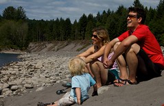
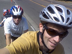
Bryce, his cousin-in-law Adam and myself rode from downtown Portland to Oxbow park. The route we took was something like this but with about 15 more miles added on.
The ride took us out the length of the Springwater Trail to Gresham, and from there, we zigged and we zagged through farmland (mainly huge nurseries; next time you're at Home Depot and wonder where all the little trees come from, wonder no more; they most likely come from all around Portland) until we finally found Oxbow Park (yeah... we got a little lost).
The park is on the shores of the Sandy River. Our wonderful wives and kids met us there with all sorts of yummy food (but no beer - we were dying for beer). After a nice picnic, we made our way down to the water for some swimming and rolling naked in the sand.
It was a great way to spend a day.
31 July 2008
26 July 2008
a bicycle built for four
Liam has been eying the tandem for a while, wondering when we'd turn it into the engine for the McLeod family bike-train.
Well, people, today was that day!
We hooked the tandem up to Liam's trail-a-bike, which, in turn was hooked up to Camper's Chariot, and took it for a ride around the farmlands of Hillsboro.
We had a blast, and will be taking the train out again in the near future - maybe for the Providence Bridge Pedal!
23 July 2008
What's with all the h8ers?
There's been a rash of biker vs. motorist crap in Portland recently (I'm trying to find links to stories, but the Oregonian's web site absolutely blows; seriously, one of the worst news sites out there), and I for one would like to know what the hell is going on. People, what the HELL is going on here?
Can't we all just get along?
I mean really, this is childish.
There are assholes behind the wheel and assholes on saddles (I'm talking figurative, people) - it's a fact of life. But to paint either "side" with a single brush is craziness. I like to ride my bike as much as possible, but I also have to drive a car. So where does that put me? Where does that put most people?
Frankly, I blame The Oregonian. Aside from a shitty web site, they sensationalize stories worse than local TV news. This creates an atmosphere of mis-trust, and even worse, hatred (which, in turn, feeds the sensationalism...).
They actually ran a story (I wish I could find it, but as I already wrote, their web site is horrible) about a guy who wrote in his blog about nearly hitting a cyclist. Apparently, the cyclist blew a stop sign and did not have a light on his bike. The guy was all pissed off because he felt that the cycling community needs to do more in regard to pushing safety, and that they/we should support laws that require lights.
The comments that followed were a series of harsh back-and-forth between bikers and motorists (or, at least, people that put themselves in either camp). But I think everyone was missing the point. Why did the Oregonian run the story in the first place? Is is news? No. Did an editor point out to the reporter or the blogger that there are ALREADY laws in place that require lights?!
Clearly, the biker (if there really was one) was in the wrong and breaking the law. That's going to happen.
It would be like me writing in this blog something about drivers are patently unsafe and it's time the motoring community backed speed limits - and The Oregonian running it.
Can't we all just get along (and ignore The Oregonian and all sensationalist media that is just trying to sell papers)?
22 July 2008
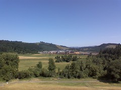
Sunday family ride
Another Sunday, another family ride. This time we rode along the bike trails on the east and west banks of the Willamette from downtown Portland into the Sellwood neighborhood (my new favorite Portland neighborhood. The more I see of PDX, the more I really like the east neighborhoods.) and back again. It was roughly 14 miles, and was highlighted with stops in the Sellwood Park and Grand Central bakery.
View Larger Map
The Eastbank Esplanade and Springwater trail are havens for biker families (and bikers without kids - there just happened to be A LOT of families out riding - and walkers, and rollerbladers... ) out for a Sunday ride. It was so much fun to get out and see everyone enjoying the amazing weather and each others' company.
We were joined by our friends Erica and Phillip. Nikki and Erica went to UNH together and she and Phillip have been in PDX for several years now.
20 July 2008
first tandem ride in a while
Nikki and I busted out the tandem for a road ride through the Hillsboro Hills. It was the first time we've been on it in a couple of years, due to babies and laziness.
I forgot about how much fun it can be to be riding so close. We're able to carry on conversations and work together.
I just have to remember to tune it before we take it out again - that clicking noise and the lack of gears can get annoying!

I forgot about how much fun it can be to be riding so close. We're able to carry on conversations and work together.
I just have to remember to tune it before we take it out again - that clicking noise and the lack of gears can get annoying!
19 July 2008
The dude BROKE HIS BIKE IN HALF, bent a metal pole... and walked away!
I was watching the stage on TV and kept rewinding this scene. I can't believe he walked away from an accident that snapped his bike in half and bent the street sign pole!
Not only did he walk away, but he hopped on a new bike and finished the stage.
Now what was that crap about Tiger Woods being the world's greatest athlete? He plays golf people (now, I'm not saying that golf is not challenging, but I will say that it is no athletic feat). Any of the guys in the Peloton would eat Tiger for lunch - they would have to; imagine how many calories a day they go through? The answer is roughly 5000.
18 July 2008
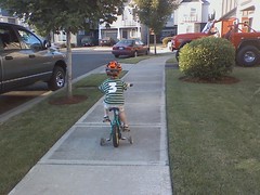
future wearer of the yellow jersey
We've been using the trail-a-bike so much that we almost forgot about Liam's bike.
Tonight, we were hanging out in the driveway so the boys could play with their sidewalk chalk when Camper came out of the garage with Liam's bike, saying, "bike? Bike?" Of course, Camper's a bit too small to ride (much to his disappointment) so he ran behind as Liam took off.
By the end, Liam had ridden around the block a half dozen times and was barely relying on the training wheels.
I nearly cried.
17 July 2008
the lapsed rider
In the ski industry (once upon a time, I had a job...), there is a term for people that haven't skied in a while; "lapsed skier." Most of the time, the reason for the lapse is kids and family.
I guess you could say I'm a "lapsed biker." I've barely ridden for two years; I went on a few road rides last year, and not one mountain bike ride. Now, in the past few weeks, I've ridden several hundred miles and the addiction is once again coursing through my veins. Seriously, I get a tick if I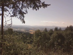 haven't ridden, and all I can think about is my next ride. Total junkie.
Biking is the only thing I can do as an adult that fully brings me back to being a kid (well, that and swinging - I love hopping on a swing), and I love that.
I forgot how good the burn can feel (seriously, it's a weird combination of ecstasy and agony), and how amazing it is to reach the top of a climb, look down, and think, "I was just there!" Then, of course, there's the downhill. There really isn't much in life that's more fun than hauling ass down a mountainside gripping the bars of a bike.
My appetite has shot up and I'm eating ... well, I'm probably eating like a normal person (if normal people inhale Powerbars and swill Hammer Gel during the day), but it sure feels like a lot. Although, a healthy appetite is not the best thing when you're unemployed. Makes it hard to buy the food your body wants to eat!
Most lapsed skiers result from having kids and not having the time to ski anymore, nor the inclination to spend the money needed to take a family skiing. While a large part of my lapse is the result of having kids, another factor was my job working nights. Which is funny, because a big part of why I accepted the job in the first place was because I felt that it would give me more time to ride. I was wrong. As it turned out, I had less time to ride (uhhh... I was sleeping), and when I was awake, I just didn't have the energy.
Oh well. None of that matters. I'm unemployed now and can ride as much as I want (he says with a nervous grin on his face...). Think I'll go for a ride in the morning.
I guess you could say I'm a "lapsed biker." I've barely ridden for two years; I went on a few road rides last year, and not one mountain bike ride. Now, in the past few weeks, I've ridden several hundred miles and the addiction is once again coursing through my veins. Seriously, I get a tick if I
haven't ridden, and all I can think about is my next ride. Total junkie.Biking is the only thing I can do as an adult that fully brings me back to being a kid (well, that and swinging - I love hopping on a swing), and I love that.
I forgot how good the burn can feel (seriously, it's a weird combination of ecstasy and agony), and how amazing it is to reach the top of a climb, look down, and think, "I was just there!" Then, of course, there's the downhill. There really isn't much in life that's more fun than hauling ass down a mountainside gripping the bars of a bike.
My appetite has shot up and I'm eating ... well, I'm probably eating like a normal person (if normal people inhale Powerbars and swill Hammer Gel during the day), but it sure feels like a lot. Although, a healthy appetite is not the best thing when you're unemployed. Makes it hard to buy the food your body wants to eat!
Most lapsed skiers result from having kids and not having the time to ski anymore, nor the inclination to spend the money needed to take a family skiing. While a large part of my lapse is the result of having kids, another factor was my job working nights. Which is funny, because a big part of why I accepted the job in the first place was because I felt that it would give me more time to ride. I was wrong. As it turned out, I had less time to ride (uhhh... I was sleeping), and when I was awake, I just didn't have the energy.
Oh well. None of that matters. I'm unemployed now and can ride as much as I want (he says with a nervous grin on his face...). Think I'll go for a ride in the morning.
16 July 2008
The Henry Hagg Half-Century
I rode the longest ride I've been on in at least a year today. I'm calling it the Henry Hagg Half-Century, because its a loop out and around Henry Hagg Lake.... and it's 50 miles...
I started the ride along my usual route, but this time, instead of staying on Iowa Hill Road, I climbed over Fern Hill and down into (I think it's called) the Tualatin Valley, where I rode along Old Highway 47 and up to and around Henry Hagg Lake.
The road that goes around the lake has a lot of vertical to it it, with many, many uphills and downhills (I guess you could call it "rolling"). A loop around the lake brought me back to where I started, so I rode back down into the valley.
Instead of re-tracing my steps, I rode through Gaston, across the TV Highway (new Highway 47) and into Laurelwood. I then followed Laurelwood Road up and onto the ridge that runs between Iowa Hill and Bald Peak. The climb is crazy-steep and at times really, really hurt!
The rewards for the hurting include amazing views of Mt. Hood and a nice, long downhill down Bald Peak Road, bringing me back to the intersection of Routes 219 and 208/10 (SW Farmington Road). I followed SW Farmington Rd. to Rood Bridge Road which brings me home.
The ride was just over 50 miles, with 3331 feet of vertical, and it took me exactly four hours.
I wish I could show you examples of sections of the ride, but I created the map in Bikely, and as I've already ranted before, there are a lot of sucky aspects to their site, and this is one. Another one: I can't print my map. Hello? Can't print your own maps?!
the itch to ride
Do I go for a ride, or look for a job?
Let's see, riding makes me feel alive and strong (except for the end of the ride, which leaves me weak and tired - but that's the point, isn't it?), gets me out breathing fresh air and seeing sites I haven't ever seen before (I love scoping out new rides).
Looking for a job makes me feel worthless and impotent. My dad would have told me to get out there and "beat the street" looking for a job, but that's not how it works anymore. Now, if one wants a job, they troll through Craigslist, Jobdango, and all of the individual companies' HR sites.
 I've sent countless emails, worked what few connections I have, and I've barely gotten a nibble. I was interviewed for a position at a web design firm a few weeks ago, but haven't heard ANYTHING. Do I send them another email?
I applied for a job last week that I think would be perfect for me, but I haven't heard back from them (then again, the closing date isn't until a week from tomorrow, so I shouldn't expect anything until then).
OK... so back to my original question. Ride, or sit in front of my computer? I think I already answered myself... see you after the ride.

Let's see, riding makes me feel alive and strong (except for the end of the ride, which leaves me weak and tired - but that's the point, isn't it?), gets me out breathing fresh air and seeing sites I haven't ever seen before (I love scoping out new rides).
Looking for a job makes me feel worthless and impotent. My dad would have told me to get out there and "beat the street" looking for a job, but that's not how it works anymore. Now, if one wants a job, they troll through Craigslist, Jobdango, and all of the individual companies' HR sites.
I've sent countless emails, worked what few connections I have, and I've barely gotten a nibble. I was interviewed for a position at a web design firm a few weeks ago, but haven't heard ANYTHING. Do I send them another email?I applied for a job last week that I think would be perfect for me, but I haven't heard back from them (then again, the closing date isn't until a week from tomorrow, so I shouldn't expect anything until then).
OK... so back to my original question. Ride, or sit in front of my computer? I think I already answered myself... see you after the ride.
14 July 2008
the Oregon Zoo adventure
So Liam and I headed to the Oregon Zoo at Washington Park last week. When faced with the choice of walking or riding my bike, I always go with my bike. We rode our bike to the Max stop; the very first one on the blue line. I did this because I knew that getting on the train with Liam, my bike and his trail-a-bike was going to be hectic. And I knew it would be 10-times worse on the return trip. I knew this, and yet I continued with my plan.
We hopped on an empty train in Hillsboro several minutes before it left. We had time to hang both bikes on the racks and take a seat. The train filled up as it made its way through Beaverton, and was pretty packed as we headed into the tunnel.
I told Liam that as soon as the train stopped, he was to hop off the train and stand near the wall - I was going to grab both bikes and follow. The train stopped - and he refused to get off without me. I grabbed his trail-a-bike and ran off the train and told him to follow me. I sprinted to the wall and practically tossed his bike against it.
"Stand here!" I shouted, and ran back to the train, which now had several more people in the doorway. My bike was on the opposite side of the train, so I busted through the wall of people with lame shouts of "pardon me" and "excuse me." I grabbed my bike, hooking it on some guy's backpack and dragging him and the Breezer toward the now-chiming-and-flashing door.
I saw Liam standing at the wall watching me wrestle through the crowd as the doors closed on the back wheel of my bike. I yanked it free and ran across the platform for him.
I knew getting home was going to suck. I then said many, many bad kind of words to that little obsessive bicyclist-dude that lives in my brain. He laughed.
 We enjoyed our day at the zoo, but I was watching the clock. I wanted to be down in the tunnel by 3:00 pm so we could miss the rush. Of course, we weren't down there until 3:30, and a blue line train was just coming into the station as we came onto the platform.
It was packed, and I hadn't even taken the bikes apart yet. We watched the train pull away. I took the bikes apart and we waited for the next train. It was a red line train to Beaverton Transit Center. It wasn't very crowded, but I figured that since it wasn't going all the way to Hillsboro, we'd let it pass.
Ten-or-so minutes later, a blue line to Hillsboro pulls in, and it is freaking packed. There must have been three bikers standing with their bikes next to each hanging bike (uhh, TriMet, get the drift, install more bike hooks. please?). We had no choice but to to pass, or hop on and be total assholes, but I'll save that lesson for another day...
 A few minutes after that, another red line to Beaverton Transit Center came in. It was pretty empty, so we hopped on. I figured I would see how things look at the Beaverton TC.
We arrived at the station and watched several packed blue line trains move through. I also watched the clock move past 5 pm. I realized that it wasn't going to get any better where we were for several more hours.
I put the bikes back together and said to Liam, "we've got them, we might as well use them!" We rode though Beaverton, staying mainly on the sidewalk that runs along the TV Highway toward Hillsboro.
At SW 153rd, we hopped on a paved path that brought us to the entrance of the Tualatin Hills Nature Park where we road a paved path to the Merlo Rd/SW 158th Ave MAX Station. I popped the bikes apart and a minute-or-so later an almost-empty blue line train pulled in.
We hopped in, I hung the bikes up, and Liam fell asleep on my lap.

We hopped on an empty train in Hillsboro several minutes before it left. We had time to hang both bikes on the racks and take a seat. The train filled up as it made its way through Beaverton, and was pretty packed as we headed into the tunnel.
I told Liam that as soon as the train stopped, he was to hop off the train and stand near the wall - I was going to grab both bikes and follow. The train stopped - and he refused to get off without me. I grabbed his trail-a-bike and ran off the train and told him to follow me. I sprinted to the wall and practically tossed his bike against it.
"Stand here!" I shouted, and ran back to the train, which now had several more people in the doorway. My bike was on the opposite side of the train, so I busted through the wall of people with lame shouts of "pardon me" and "excuse me." I grabbed my bike, hooking it on some guy's backpack and dragging him and the Breezer toward the now-chiming-and-flashing door.
I saw Liam standing at the wall watching me wrestle through the crowd as the doors closed on the back wheel of my bike. I yanked it free and ran across the platform for him.
I knew getting home was going to suck. I then said many, many bad kind of words to that little obsessive bicyclist-dude that lives in my brain. He laughed.
We enjoyed our day at the zoo, but I was watching the clock. I wanted to be down in the tunnel by 3:00 pm so we could miss the rush. Of course, we weren't down there until 3:30, and a blue line train was just coming into the station as we came onto the platform.It was packed, and I hadn't even taken the bikes apart yet. We watched the train pull away. I took the bikes apart and we waited for the next train. It was a red line train to Beaverton Transit Center. It wasn't very crowded, but I figured that since it wasn't going all the way to Hillsboro, we'd let it pass.
Ten-or-so minutes later, a blue line to Hillsboro pulls in, and it is freaking packed. There must have been three bikers standing with their bikes next to each hanging bike (uhh, TriMet, get the drift, install more bike hooks. please?). We had no choice but to to pass, or hop on and be total assholes, but I'll save that lesson for another day...
A few minutes after that, another red line to Beaverton Transit Center came in. It was pretty empty, so we hopped on. I figured I would see how things look at the Beaverton TC.We arrived at the station and watched several packed blue line trains move through. I also watched the clock move past 5 pm. I realized that it wasn't going to get any better where we were for several more hours.
I put the bikes back together and said to Liam, "we've got them, we might as well use them!" We rode though Beaverton, staying mainly on the sidewalk that runs along the TV Highway toward Hillsboro.
At SW 153rd, we hopped on a paved path that brought us to the entrance of the Tualatin Hills Nature Park where we road a paved path to the Merlo Rd/SW 158th Ave MAX Station. I popped the bikes apart and a minute-or-so later an almost-empty blue line train pulled in.
We hopped in, I hung the bikes up, and Liam fell asleep on my lap.
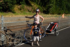
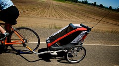
our beloved Chariot
We've had the Chariot since shortly before Liam was born (close to four years now) and the thing hasn't let us down yet. It was our main stroller until kid-number-two (Campbell) came along and we needed the services of a tandem-stroller, so now it pretty much lives with the trailer-bar on full-time (it even has a new life as the caboose in our bike train).
If you're looking to buy a trailer, seriously consider a Chariot. It's safety is second-to-none, with big, beefy wheels, a solid aluminum frame and 5-point harness. I can say from experience that it self-rights and the harness holds the kid right in place - explanation: I was walking the bike and trailer around a gate and misjudged the width between two large rocks. A wheel went up on a rock, the trailer started to tip (Liam had a great look on his face; that perfect combination of fear and joy), and I pulled the bike forward, which caused the trailer to right itself (Liam had a relieved look on his face) and land on both wheels.
If you're looking to buy a trailer, seriously consider a Chariot.
It's safety is second-to-none, with big, beefy wheels, a solid aluminum frame and 5-point harness. I can say from experience that it self-rights and the harness holds the kid right in place - explanation: I was walking the bike and trailer around a gate and misjudged the width between two large rocks. A wheel went up on a rock, the trailer started to tip (Liam had a great look on his face; that perfect combination of fear and joy), and I pulled the bike forward, which caused the trailer to right itself (Liam had a relieved look on his face) and land on both wheels.Multi-uses
- It's a great stroller that will go places most other strollers wouldn't come close to.
- With the cross-country ski kit attached, it's fun to drag along on a winter adventure.
- We have a jogging attachment, but never use it because the front wheels for the stroller work fine! And then there's the whole I-don't-run-thing.
- A sleek, bike trailer that tracks so nicely.
first "just the two of us" ride in a looong time

Nikki and I went for a ride this morning. She didn't have to be at school until 1:00 pm, so we dropped the kids off at school and went for a "just the two of us" ride. It was the first time in a really, really long time.... and it was fun. Now we'll have to get the tandem rolling!
We rode the Hillsboro Hills ride that I've been using as the basis for most of my rides. It's a little over twenty miles of rolling farmland - and when I say rolling, I don't mean mean gently. I can't believe how steep some the fields are!
 The ride starts out fairly flat and is fun to crank through in the big ring. There are places where the road turns ninety degrees around someone's property. The nicely banked corners and little traffic make it fun to scream through these corners and pop out with some good speed.
The Iowa Hill section was a little rough on Nikki, as it was her first hill climb of the season (and maybe the fact that she had woken up early to swim laps...), but she powered her way to the top and was rewarded with a great view of Mt. Hood and the upper Willamette Valley.
I love you bikely.com. I hate you bikely.com...
I've discovered a great site that does much of what I've been wanting to do (grumble, grumble....), that is, to make online maps of bike rides, and make them searchable.
The site is called bikely.com and while they seem to be on the right track, there are a few issues I have with them. For starters, I only see a white page when I visit them with Firefox, so I have to open Safari. I think it's a Mac thing - I've had that happen with some sites that use iFrames or Javascript.
You can either upload data from a GPS unit, or draw a map on a Google map. The drawing option snaps to streets, so it makes it really easy. You also get an elevation profile for the route - I love that stuff.
However, sharing the maps isn't easy. When I cut and paste the code they give me to embed the map in my blog, the area where the map should be is white.Now, again, that could be my Mac, or it could be the warning they post about the fact that the code may not work with your blog software. It appears to be Firefox, as this appears fine on Safari.Whatever. Is still pisses me off.
I'd love to show you a list of the maps I've created, but the link they give me is retarded (sorry - but seriously... it is. Go ahead. Click the link.).
You're on the right track bikely, but you could be so much better.
The site is called bikely.com and while they seem to be on the right track, there are a few issues I have with them. For starters, I only see a white page when I visit them with Firefox, so I have to open Safari. I think it's a Mac thing - I've had that happen with some sites that use iFrames or Javascript.
You can either upload data from a GPS unit, or draw a map on a Google map. The drawing option snaps to streets, so it makes it really easy. You also get an elevation profile for the route - I love that stuff.
However, sharing the maps isn't easy. When I cut and paste the code they give me to embed the map in my blog, the area where the map should be is white.
I'd love to show you a list of the maps I've created, but the link they give me is retarded (sorry - but seriously... it is. Go ahead. Click the link.).
You're on the right track bikely, but you could be so much better.
Sauvie Island family ride
We went out to Sauvie Island yesterday for a family ride. It was scenic - we watched the Mt. Adams wildfire grow - but the roads are narrow with a ton of traffic. It kind of reminded me, and Nikki remarked on the same thing later, of Martha's Vineyard, but without all the houses (and the floating houses just aren't the same thing!).
I'm glad we took it in - we rode by a field that grows potatoes for Tim's Chips, and we went to a beach (that had a lot of trash strewn about - what's up with that?!) - but I don't see us headed in that direction again.

I'm glad we took it in - we rode by a field that grows potatoes for Tim's Chips, and we went to a beach (that had a lot of trash strewn about - what's up with that?!) - but I don't see us headed in that direction again.
11 July 2008
A great sunset ride in Concord
If time was running out and I needed to take maximum advantage of the dwindling daylight, I would ride a loop in East Concord that climbs Oak Hill, an eastern hill of the Merrimack Valley, and catch that last bit of daylight - a good half-hour after the sun had set in Concord.
View Larger Map
I start the ride the same way I start the Concord/Hopkinton Ride, but veer RIGHT at the intersection of Carter Hill Road and Lake View. This follows Penacook Lake (the Concord Reservoir) around to North State Street (Route 3).
I could have detoured the ride around the reservoir by starting on North State Street, but I avoid riding that road as much as possible.
A few hundred feet down North State, stay right onto Sewalls Falls Road and follow that to the bridge. The Sewalls Falls Bridge is an old, one-lane, steel-grid bridge. It sucks to walk across in cleats, so just ride like hell, don't try to turn, don't try to stop, and don't look down - well, actually, do look down, it's pretty crazy!
After you cross the river, you'll pass the Concord Monitor - say hello for me - and cross under the highway. Take a left at the intersection, then the first right.
View Larger Map
Follow Sanborn Road to the end and turn right on Hoit. Go straight at the intersection of Shaker and Old Shaker (sometimes there are Shakers there on opposite sides of the street yelling at each other), where Hoit becomes School. That is one crazy intersection...
View Larger Map
Ride School Street to Oak Hill Road. Much of School Street is a gradual downhill. Use that to recover from the climb up Hoit, because there's one last uphill to go. After turning onto Oak Hill, the route ascends steeply before rewarding the rider with a long downhill into Concord.
At the bottom of the hill (now called Shawmut Street), turn left onto Eastside Drive, maneuver past the vehicles attempting to enter and exit Interstate 93, and turn left onto Eastman Street (stop off at Quality Cash for some well deserved kabobs) and follow it to the end.
View Larger Map
At the end, take the path that parallels the highway on the highway bridge.
View Larger Map
Follow the path to the Tech, cross the highway on Delta Drive, and ride through the much-vaunted, answer-to-Concord's-troubles, Horseshoe Pond revitalization project (a conference center and office buildings on the old Concord Lumber site). Instead of riding up onto 393, cross the tracks and head up past Franklin Pierce's homestead, a nice way to end the ride!
View Larger Map
I start the ride the same way I start the Concord/Hopkinton Ride, but veer RIGHT at the intersection of Carter Hill Road and Lake View. This follows Penacook Lake (the Concord Reservoir) around to North State Street (Route 3).
I could have detoured the ride around the reservoir by
starting on North State Street, but I avoid riding that road as much as possible.A few hundred feet down North State, stay right onto Sewalls Falls Road and follow that to the bridge. The Sewalls Falls Bridge is an old, one-lane, steel-grid bridge. It sucks to walk across in cleats, so just ride like hell, don't try to turn, don't try to stop, and don't look down - well, actually, do look down, it's pretty crazy!
After you cross the river, you'll pass the Concord Monitor - say hello for me - and cross under the highway. Take a left at the intersection, then the first right.
View Larger Map
Follow Sanborn Road to the end and turn right on Hoit. Go straight at the intersection of Shaker and Old Shaker (sometimes there are Shakers there on opposite sides of the street yelling at each other), where Hoit becomes School. That is one crazy intersection...
View Larger Map
Ride School Street to Oak Hill Road. Much of School Street is a gradual downhill. Use that to recover from the climb up Hoit, because there's one last uphill to go. After turning onto Oak Hill, the route ascends steeply before rewarding the rider with a long downhill into Concord.
At the bottom of the hill (now called Shawmut Street), turn left onto Eastside Drive, maneuver past the vehicles attempting to enter and exit Interstate 93, and turn left onto Eastman Street (stop off at Quality Cash for some well deserved kabobs) and follow it to the end.
View Larger Map
At the end, take the path that parallels the highway on the highway bridge.
View Larger Map
Follow the path to the Tech, cross the highway on Delta Drive, and ride through the much-vaunted, answer-to-Concord's-troubles, Horseshoe Pond revitalization project (a conference center and office buildings on the old Concord Lumber site). Instead of riding up onto 393, cross the tracks and head up past Franklin Pierce's homestead, a nice way to end the ride!
10 July 2008
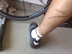
bike tatts
Something I think many people are familiar with.
Even if you try to avoid them, they will happen. At least this time they didn't hurt. I've returned from other rides with blood mixed in with the grease and dirt.
Either way, a good scrubbing with soap and water generally does the trick.
Even if you try to avoid them, they will happen. At least this time they didn't hurt. I've returned from other rides with blood mixed in with the grease and dirt.
Either way, a good scrubbing with soap and water generally does the trick.
09 July 2008
Up and over the mountain
I decided to see what was over the mountain.
I rode to the other sides of Iowa and Spring Hills. The ride is roughly 34 miles, and while it's mainly smooth pavement, there are two gravel road sections that total about a mile-and-a-half. It's full of climbs and descents, and of course, incredible vistas (but I would recommend stopping for those).
View Larger Map
I started by ride going down SW Minter Bridge Road, but was turned back by a downed power line. I detoured over to SW Rood Bridge Road and rode that to SW Grabel, and up to SW Tongue Lane. It's the same basic ride as the Hillsboro Hills ride, but you turn onto SW Nursery Road.
View Larger Map
At the end of SW Nursery Road, take a right on SW Hergert. The road goes straight despite the fall line, which results in a fun roller coaster ride. I came to the top of the first rise to see two huge turkey vultures eating road kill.
View Larger Map
Take a left on the brand new pavement of SW Blooming Fern Road and enjoy the climb. Take a left at the bottom of a small descent and follow SW Fern Hill Road to where it ends at SW Spring Hill Road. Take a left, and follow the road.
I stayed straight at SW Hardebeck Road and ran into about a half-mile of hard-packed gravel.
View Larger Map
Turn left on SW Dixon Mill Road and climb straight up out of the valley. It's amazing how straight the road goes! The road has the decency to stay paved for the climb. It becomes a hard-packed (and oil-soaked in some sections) gravel road for a section that runs down a slight incline.
The pavement returns in time for some fast descents around some perfectly banked corners! Before long, you hook up with SW Unger road and drop down what I like to call, the Unger Drop and Twist ... and Drop, a a two-hundred vertical foot straight drop in a quarter mile, with a crazy "S-corner," followed by another straight shot descent into the valley. You should try it sometime!
View Larger Map
I then turned left on 219, and rode that to 208/10, where I took another left. I rode that back to Rood Bridge Road, and back into Hillsboro.
The Orgasmatron
... is what I would rename SW Gnos Road to. At the end, it leaves you shaking and wanting more.
It's a 3-mile out-and-back, or, in this case, up-and-down, as it ascends 600 feet in a mile and a half. It's a spur off of the Spring Hill Ride.
The first part of the ride goes straight up out of the farmland, with barely a curve.
View Larger Map
It may look like a field on a satellite picture, but look at the same section of land on a topo map!
View Larger Map
The views as you ascend are spectacular, with views of all the peaks in the Cascades. Another thing you'll notice is the brand new pavement. That's the nice thing about riding up what you'll soon be riding down; you cam scope out your line!
At the top is a commercial nursery, with rows and rows of various trees and plants.
View Larger Map
The road turns to gravel shortly after descending a bit off the top, so I'd recommend turning around at the top, putting your bike into it's lowest gear, and start cranking!
You start at 800 vertical feet and a mile-and-half later, you're at 200 vertical feet, and you'll see why I would rename this particular road.
View Larger Map
08 July 2008
Spring Hill
A ride into the hills around Hillsboro. About 23 miles.
View Larger Map
Start by going down River Road and turning right onto Minter Bridge Road. Once you get past the "Entering Agricultural Zone" sign, you're on your own - seriously, be careful, the roads are narrow, and while they are not, in any way congested, they do tend to have rather large trucks on them!
View Larger Map
Turn right onto SW Grabel, and again onto Route 219. A quick ride on the wide shoulder, brings you to SW Tongue Road. Take a left. This whole area is a nice flat, big gear, crankfest. Ride Tongue Road out past the golf course.
View Larger Map
Left onto SW Iowa Hill Road and start to climb. Follow the road to SW Unger, drop down over the edge and hang on! The road drops a couple of hundred vertical feet in an almost straight drop, with an s-corner thrown in for good measure.
View Larger Map
Follow the road to Route 219. Take a right and ride to Route 10/208 (Farmington Road), and take a left.
View Larger Map
Left at Rood Bridge Road. This road is a blast to ride. The pavement is mostly new and smooth, and the road has a bunch of right-angle curves with perfectly banked corners.
Rood Bridge Road ends up back at River Road.
View Larger Map
View Larger Map
Start by going down River Road and turning right onto Minter Bridge Road. Once you get past the "Entering Agricultural Zone" sign, you're on your own - seriously, be careful, the roads are narrow, and while they are not, in any way congested, they do tend to have rather large trucks on them!
View Larger Map
Turn right onto SW Grabel, and again onto Route 219. A quick ride on the wide shoulder, brings you to SW Tongue Road. Take a left. This whole area is a nice flat, big gear, crankfest. Ride Tongue Road out past the golf course.
View Larger Map
Left onto SW Iowa Hill Road and start to climb. Follow the road to SW Unger, drop down over the edge and hang on! The road drops a couple of hundred vertical feet in an almost straight drop, with an s-corner thrown in for good measure.
View Larger Map
Follow the road to Route 219. Take a right and ride to Route 10/208 (Farmington Road), and take a left.
View Larger Map
Left at Rood Bridge Road. This road is a blast to ride. The pavement is mostly new and smooth, and the road has a bunch of right-angle curves with perfectly banked corners.
Rood Bridge Road ends up back at River Road.
View Larger Map
Concord/Hopkinton
A little short of 25 miles, this quick ride includes two decent hill climbs (and descents), as well as some great scenery, fast pavement, and a bike path.
View Larger Map
Start out at Dewey School - at the intersection of Centre, Liberty and Auburn Streets. Ride up Auburn Street (northwest).
View Larger Map
Take a left at the intersection of Lake View and Carter Hill. And climb on up Carter Hill! It's a fast uphill with two pitches. The first climbs steeply and wraps around two corners. At the top of the second corner, the terrain levels out a bit and you face the rest of the climb in one straight shot.
View Larger Map
At the bottom of Carter Hill, take a left and ride over the river.
View Larger Map
Ride for a few miles, take a left at Penacook Road, and cross the river again.
View Larger Map
Take a left at Gould Hill Road - and go STRAIGHT up!
View Larger Map
Follow Gould Hill Road down to Hopkinton Road and ride into the center of Contoocook. Follow Main Street toward Concord, into the horrible, highway-like off ramp for I-89.
View Larger Map
Take a right on Jewett Road, cross over the highway and take a left on Farrington Corner Road. Farrington has a long, gradual downhill that's fun to crank down at high speeds. Turn left at the stop sign (Stickney Hill Road) and ride up a gradual, straight uphill, then down a hill. At the bottom of Stickney Hill, stay right and hop onto the bike path that rides perpendicular to I-89.
View Larger Map
At the end of the bike path, turn left on Silk Farm Road, and ride under the highway and around the crazy corner.
View Larger Map
Take a right at the end of the road and ride through St. Paul's. Take a right onto Pleasant Street and ride past the hospital. Turn left onto Warren Street and ride past the high school.
View Larger Map
Turn left on Liberty, go two streets over, and you're back where you started!
View Larger Map
Start out at Dewey School - at the intersection of Centre, Liberty and Auburn Streets. Ride up Auburn Street (northwest).
View Larger Map
Take a left at the intersection of Lake View and Carter Hill. And climb on up Carter Hill! It's a fast uphill with two pitches. The first climbs steeply and wraps around two corners. At the top of the second corner, the terrain levels out a bit and you face the rest of the climb in one straight shot.
View Larger Map
At the bottom of Carter Hill, take a left and ride over the river.
View Larger Map
Ride for a few miles, take a left at Penacook Road, and cross the river again.
View Larger Map
Take a left at Gould Hill Road - and go STRAIGHT up!
View Larger Map
Follow Gould Hill Road down to Hopkinton Road and ride into the center of Contoocook. Follow Main Street toward Concord, into the horrible, highway-like off ramp for I-89.
View Larger Map
Take a right on Jewett Road, cross over the highway and take a left on Farrington Corner Road. Farrington has a long, gradual downhill that's fun to crank down at high speeds. Turn left at the stop sign (Stickney Hill Road) and ride up a gradual, straight uphill, then down a hill. At the bottom of Stickney Hill, stay right and hop onto the bike path that rides perpendicular to I-89.
View Larger Map
At the end of the bike path, turn left on Silk Farm Road, and ride under the highway and around the crazy corner.
View Larger Map
Take a right at the end of the road and ride through St. Paul's. Take a right onto Pleasant Street and ride past the hospital. Turn left onto Warren Street and ride past the high school.
View Larger Map
Turn left on Liberty, go two streets over, and you're back where you started!
Beginings
My first post on my blog that started as a BIG idea and ended up as blog...
Sort of. Since this is my first post, it's the beginning of something. Maybe that something will grow into the BIG idea it was intended to be.
I'm currently unemployed and living in Hillsboro, Oregon. I love riding bikes - nothing else can put you in touch with your inner five-year-old like a bike - so I figure I might as well ride as much as possible.
The only problem was, I really couldn't find any good suggested local rides, and/or maps. Hillsboro sits in a valley, and as someone that loves riding hills, I've been looking at the hills in the distance, and pouring over Google Maps of the area.
That brings in another thing I love to do; make online maps. My idea is to make usable bike maps. Show routes that are fun, recreational rides, or safe commuting paths into an urban space. I'll sprinkle in a few photos, and maybe some video.
I wasn't really sure where to start, so I started with a map of a ride I've been playing with in the hills around Hillsboro. I'll blog it later. Check it out and let me know what you think.
Subscribe to:
Posts (Atom)