I rode the longest ride I've been on in at least a year today. I'm calling it the Henry Hagg Half-Century, because its a loop out and around Henry Hagg Lake.... and it's 50 miles...
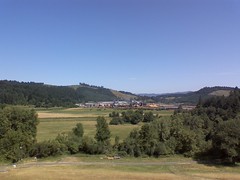
I started the ride along my usual route, but this time, instead of staying on Iowa Hill Road, I climbed over Fern Hill and down into (I think it's called) the Tualatin Valley, where I rode along Old Highway 47 and up to and around Henry Hagg Lake.
The road that goes around the lake has a lot of vertical to it it, with many, many uphills and downhills (I guess you could call it "rolling"). A loop around the lake brought me back to where I started, so I rode back down into the valley.
Instead of re-tracing my steps, I rode through Gaston, across the TV Highway (new Highway 47) and into Laurelwood. I then followed Laurelwood Road up and onto the ridge that runs between Iowa Hill and Bald Peak. The climb is crazy-steep and at times really, really hurt!
The rewards for the hurting include amazing views of Mt. Hood and a nice, long downhill down Bald Peak Road, bringing me back to the intersection of Routes 219 and 208/10 (SW Farmington Road). I followed SW Farmington Rd. to Rood Bridge Road which brings me home.
The ride was just over 50 miles, with 3331 feet of vertical, and it took me exactly four hours.
I wish I could show you examples of sections of the ride, but I created the map in Bikely, and as I've already ranted before, there are a lot of sucky aspects to their site, and this is one. Another one: I can't print my map. Hello? Can't print your own maps?!
No comments:
Post a Comment